This article is a part of Poland Unpacked. Weekly intelligence for decision-makers
Satim is a deep-tech company founded by Jacek Strzelczyk and Stanisława Porzycka-Strzelczyk. The firm has developed a tool without which even an advanced constellation of SAR radar satellites would be practically useless.
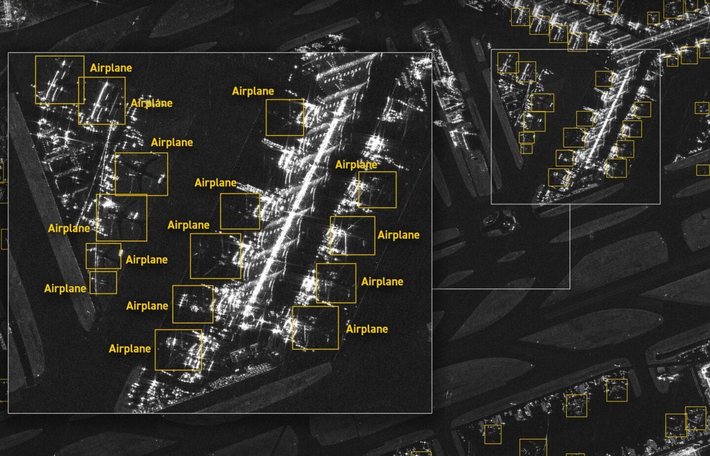
Satim created AI-based software that can extract actionable information from radar images, which are notoriously difficult to interpret. The software identifies which objects appear in the image, their location, their classification, and the confidence level of each detection.
Explainer
AGH University of Science and Technology
AGH University of Science and Technology is one of Poland’s most prestigious technical universities and a research institution. Located in Kraków, it was originally founded in 1919 as the Academy of Mining and Metallurgy, reflecting Poland's industrial heritage. Today, AGH is a comprehensive STEM powerhouse offering programs in engineering, computer science, physics, materials science, and applied mathematics, among other fields.
The company has long collaborated with Iceye, the Polish-Finnish space venture, but it is now beginning to expand into the military sector. It is also gradually preparing to raise significant capital for further development.
How the world of satellite reconnaissance is changing
SAR (Synthetic Aperture Radar) equipment has been capturing images for several decades. Initially, it was mounted on aircraft, and over time it also reached space. In recent years, the boom in space-based solutions has further boosted the popularity of SAR imagery – mainly because Iceye, the company founded by a Pole, significantly advanced the technology and now builds entire constellations of satellites with commercially available imagery.
However, SAR images bear little resemblance to the classic satellite photos familiar from Google Maps. They are noisy, monochromatic, and governed by a different physics of scene “illumination.” For example, SAR does not rely on sunlight; it uses radio pulses and the reflections of those pulses off surfaces.
As a result, analyzing what appears in an image can take an experienced analyst anywhere from several dozen minutes to more than a dozen hours. This is for a single image, in which they must identify details such as the structural elements of an aircraft to determine whether it is civilian or military, or the hull structure of a ship, allowing them to classify the type of warship.
SAR operates both day and night and can “see through” clouds, fog, and most adverse weather conditions. Almost every image can be used. By comparison, up to 80% of traditional satellite photos are unreadable due to weather conditions or nighttime.
Expert's perspective
Polish satellites and the future of the technology
Creotech Instruments actively supports the growth of Poland’s space sector through involvement in strategically important projects, such as the Mikroglob program and the PIAST initiative. The company develops both its own ground segments and communication systems, as well as software for data analysis.
The market awakens: The war in Ukraine and the end of illusions
According to Satim’s founder, it was only the war in Ukraine that made many institutions start taking satellite reconnaissance seriously – as an operational tool rather than just “pretty images” for reports. This shift has driven growing interest in SAR technology, particularly at the national level. Across Europe and beyond, new constellations are emerging that promise more frequent imagery, shorter revisit times, and higher bandwidth. Poland recently launched such a project.
Demand is rising, but supply of services is still struggling to keep up. As Jacek Strzelczyk explains, many companies worldwide have attempted SAR data analysis, but most have remained at the level of declarations. For instance, one American firm abandoned its own analytics and instead began building a platform to integrate analyses from multiple image sources – Satim is now one of its contractors. A French competitor developed a tool capable of recognizing six classes of objects; by that time, Satim was already handling 150. The French company eventually gave up, and the firm was later acquired by another player.
The Bundeswehr contract illustrates the edge of Polish technology. According to Strzelczyk, the German military received numerous offers from companies claiming to have similar capabilities. The difference? Satim arrived with a ready-to-test product.
“Germany said we were the first company that could immediately provide a finished product for testing. The others, when asked to do the same, simply disappeared,” recalls Strzelczyk.
Satim signed the contract in December, and the tool has already been deployed with the German military.
“The product already existed; we didn’t have to build it from scratch. It was delivered, and now we’re continuously expanding the catalog of object classes it can analyze,” emphasizes Satim’s founder.
Poland is buying SAR too – and it will face the same challenge
The dilemma faced by the German military is not an exception – it is the rule. Poland has launched a SAR satellite acquisition program (Microsar), and the first satellite is already in orbit. That’s a positive development, but there is a challenge: how much data will there be, and who will analyze it?
“Poland will have several hundred images a day. We will have the data, and we want to turn it into actionable information. The Ministry of Defense has understood that analytics will be essential to make full use of the system,” says Jacek Strzelczyk.
As the company’s CEO notes, Satim is in talks with the Polish side. Timing, however, will be critical.
“It would be ideal for the analytical tools to be operational before the full flow of data begins,” adds Strzelczyk.
Business model: Licensing and “per-image” services
Satim operates on multiple levels simultaneously. On one hand, it sells software as a tool installed on the client’s side – like in the German program. On the other hand, it also offers a service in partnership with satellite operators: the satellite delivers the image, Satim analyzes it, and the client receives the results.
Satim currently has around 40 employees, the vast majority of whom are technical staff – programmers, analysts, and AI specialists. Its commercial team – sales, operations, marketing – is smaller.
Although the company lists foreign addresses on its website (USA, UK), its operations are primarily based in Poland. In the UK, it has one employee and a “virtual office”; in the US, it has a legal entity but no staff. Partnerships with prime contractors play a key role in its expansion. Through such collaborations, Satim participates as a subcontractor in several American programs. In this model, the startup provides the tool but does not gain insight into exactly which data is being analyzed.
So far, Satim has raised USD 7 million in external funding. Investors include the Polish firm Balnord, as well as funds from the UK and the US and various business angels. Strzelczyk emphasizes that the vast majority of shares remain in the hands of Polish citizens or institutions.
Will there be another funding round? Negotiations are ongoing.
Ambitions are high
Satim does not want to be merely a “tool for object classification.” The company aims to become the “default technological layer” that translates various SAR images into a language users can understand.
“We operate between raw data and precise information. We want to be a layer in the value chain,” says Jacek Strzelczyk.
In the shorter term, three very concrete directions for development are emerging. First, expanding the catalog of recognizable objects. Second, adapting to new platforms – this includes next-generation satellites, different imaging modes and resolutions, as well as SAR images from aircraft and drones. Third, the creation of on-edge analytics, for example installing the tool directly on a satellite, aircraft, or drone. This approach eliminates the need to transmit large volumes of data to the ground, enabling preliminary selection and analysis directly on the device.
Satim is just the beginning
According to the fund’s CEO, Satim has the potential to become a NATO standard for detection and recognition of objects in SAR imagery. As a result, the company could integrate with command and control (C2) systems.
“Poland, already possessing its own satellites, must simultaneously build expertise in reconnaissance systems and automated detection. Only proactive efforts can provide a real advantage against external threats. We are convinced that the Polish military deserves ‘Polish eyes’ for its reconnaissance systems – modern, AI-driven, and developed by domestic engineers and scientists,” adds Marcin Kowalik.
Fireside chat
Satim is just the beginning of Poland’s success in space technology
Does Poland have the potential to build companies capable of achieving major success in niches such as SAR data analysis?
Łukasz Wilczyński, space industry expert and CEO of Planet Partners: Absolutely – and Satim is a concrete example of the current reality of the Polish market. Poland is developing companies that achieve global success in highly specialized segments of the space sector. Satim is an ideal case study of this process. The Kraków-based company quickly identified a broader application for its expertise – analyzing SAR radar data using artificial intelligence.
Is Satim an exception or the rule for Polish space technology?
Poland has a solid foundation for such successes: strong educational institutions (technical universities, including AGH, from which Satim emerged, and which recently opened the only Faculty of Space Technologies in Poland), a growing pool of experts, and infrastructure that supports innovation. Considering there are around 500 entities in the space sector, I am convinced that Satim is just the beginning of a wave of successes.
Which areas offer the most interesting opportunities for the development of Polish space technologies?
We are witnessing a phenomenon that is hard to ignore: Poland is transforming from a country interested in space technologies into a player of strategic importance for Europe. This has been driven by a series of breakthrough decisions, investments, and projects that open entirely new opportunities for competition and international cooperation. In the sector’s further development, I see five areas with significant potential. For example, Poland is already among the European leaders in using satellite data for crisis management.
Poland is also building its own satellite constellations.
Exactly. The CAMILA project – a Polish constellation of four satellites valued at PLN 860 million (EUR 2024m) – is a strategic investment. The first MikroSAR satellites were launched into orbit in November 2024. Poland will have its own high-resolution satellite data – a strategic asset in times of energy security and technological independence priorities. Poland also has recognized competencies in AI and data science. As satellites generate increasing volumes of data, the demand for advanced algorithms grows. This is a natural area for the Polish IT sector and academia.
Key Takeaways
- Implications for Polish security and future Ambitions. Satim’s international success could have significant implications for Poland’s security, as the country is simultaneously developing its own SAR capabilities. The company is already in talks with the Ministry of Defense regarding the use of its tool in the national MikroSAR satellite system. The sheer scale of the data collected means that without advanced analytics, operational use could be limited. Satim is focused on further development: adapting its system to new platforms and creating on-edge capabilities, which allow data to be analyzed directly on satellites or drones. The company’s ultimate ambition is to become the global interpretive standard for SAR imagery.
- Satim as a key player in military satellite reconnaissance. Satim is gaining international recognition as a key player in the development of military satellite reconnaissance thanks to its unique technology for automated analysis of SAR radar imagery. The Kraków-based Polish firm, emerging from AGH University of Science and Technology, has become a strategic partner of the German Bundeswehr in its satellite constellation program. Satim’s AI-driven solution allows for the rapid and precise classification of objects in SAR images, eliminating the need for specialists to manually analyze hundreds of images. The company’s technological readiness proved decisive: Satim delivered a working product for testing, while competitors offered only declarations.
- SAR technology’s growing significance and the analytical gap. The rising importance of SAR technology and the shortage of analytical tools have created a niche perfectly suited to the Polish solution. Radar reconnaissance operates independently of weather and daylight, making it a valuable source of intelligence. The challenge remains, however, in interpreting the data. With an increasing number of satellites and growing demand for rapid information, the lack of qualified analysts has become a bottleneck. Satim addresses this issue through automation and by developing a catalog that now covers nearly 300 classes of military and civilian objects.